

Community
The Insivumeh informs about the possible effects of the tropical storm Erick in Guatemala.
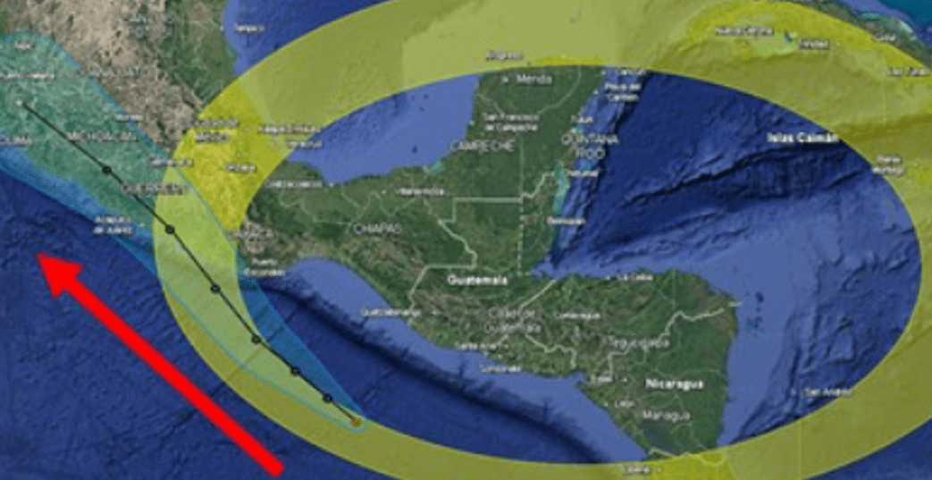
Map shows the trajectory of the tropical storm Erick. (Free Press Photo: Image shared by Insivumeh)
The weather service of the National Institute of Seismology, Volcanology, Meteorology and Hydrology (Insivumeh) reported that this Tuesday, June 17 The five-E tropical depression was strengthened and became the tropical storm Erick.
He added that this is located within the warning zone of the Tropical Cyclones Operational Plan of the Insivumeh.
He explained that, due to his career, the aforementioned tropical storm will not directly affect Guatemala, But its closeness will cause abundant income of moisture and cloudiness.
The Insivumeh stressed that rains will continue to register in the early hours of the morning, from the south to the center and north of the national territory; while in the rest of the country partial cloudy are expected with possible short periods of sun.
In the afternoon and night cloud development, with rains and electrical activity.
The largest accumulated rain are expected from the south to the center of the country, in the transverse strip of the north, valleys of the East and some areas of the West.
Because of these climatic conditions, lahares can be registered in the volcanic chain, sudden floods of rivers, floods, mass movements and damage to the country’s road network.
To read more: Guatemala has had 12 extreme heat days in the last year, 95 caused by climate change
Recommendations
- Insivumeh recommends the National Coordinator for Disaster Reduction (Conred) take into account the bulletins that emits and disseminate them in their different venues.
- To the general population, keep the updates issued by Insivumeh as an official entity.
- It is also recommended to take the necessary precautions against the planned rains, since they can cause sudden floods of rivers, floods and damage to the road network of the country and infrastructure.
- Fishermen and the general public are advised caution at the possible increase in waves and wind speed on the coast of the Pacific Ocean.
Stay updated with the bulletin now. Key information at the time it happens. Subscribe here.