

A technical report from the Mitigation Department of the National Coordinator for Disaster Reduction (CONRED) revealed the existence of active landslides on the slope located in Kilometer 61 of the Ca-09 Norte roadalso known as the Route to the Atlantic or Jacobo Arbenz Guzmán road.
The study was conducted to evaluate visible damage on the slope adjacent to the road, that connects to the capital with the northeastern country. Field visits were held on June 20 and 21, 2024, and Mountain instability was confirmedlocated in the legal of Sanarate, the progress.
According to the report, to which Guatevisión and Free press He had access, reveals that the point Affected is located on a slope that borders the road platform directly.
The unstable land puts vehicles that travel through the place, especially During the rains. The report delivered on October 7, 2024 warned that, if not intervened, New landslides could occur that affect the road and even block the passage, as happened on July 3, 2025.
At the photo feet of the images that were awarded to the report, it was indicated that the presence of “Mass movements active, longitudinal cracksaccumulation of rainwater and eroded areas ”on the slope.
In one of the most alarming photographs, they can be seen Recent undercuts at the base of the hillsidewhich suggests a loss of support that compromises the structure of the road in that section, in addition to cracks in the Cerro Corona, which show An active mass movement.
Among the main technical findings include:
- Active landslides: mass movements are observed in process, which affect the stability of the slope and generate risk on the road platform.
- Cracks and erosion: The terrain has visible cracks and areas with loss of surface vegetation, which facilitates water infiltration and increases vulnerability.
- Superficial runoff and saturation: The report mentions stormless runoff without control, which has caused the saturation of the land and accelerated erosion.
- Risk to users: The proximity of the slope to the road represents a direct threat to drivers and vehicular flow, especially during the rainy season.
This section of the road I had already presented signs of instability in previous seasonsas recorded in previous reports. However, current conditions indicate that Geological activity has continued and has intensified with recent rains.
The report concluded in 2024 by highlighting that it existed a high probability of new landslides If it does not intervene in a timely manner. As an urgent measure, the technicians recommended:
- Perform slope stabilization works, such as adequate containment walls and drains.
- Implement stormwater channeling and collection systems to reduce soil saturation.
- Install preventive signaling in the area and make constant monitoring during the rainy season.
Cracks and vibrations generate landslides
In a visit this July 4, it could be observed how there are At least 5 shouts of great visible magnitudeone of these on a rock about 4 meters high by 5 wide that is split in half, and that with the passing of the transport of heavy load, the vibrations are generating that there are small visible landslides.

In addition, a gullion was found that has left the last collapse, which leaves at risk the upper part of the hill, which works to avoid riskwhile machinery In the low park try to remove the land that obstructs the lanes.
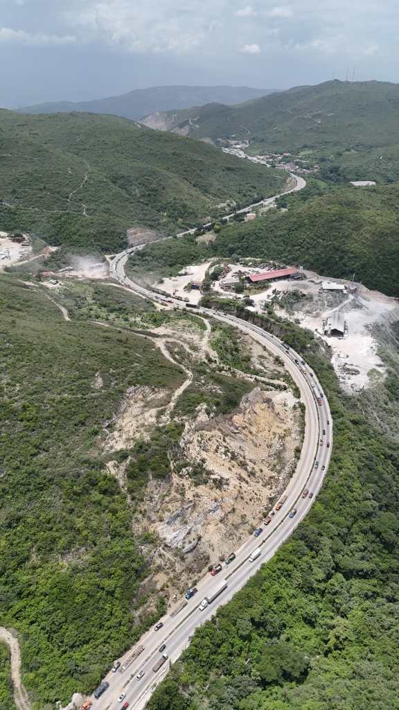
The CIV said that complying with the recommendations has been complex referred to a geological fault that crosses the areain addition to 5 different types of rock in the sector, which complicates the form of intervention.
Without advances
Kilometer 43 CA-9 North in the jurisdiction of San Antonio La Paz, El Progreso, since September 2022 various landslides on the section, However, in October 2024, the protection wall collapsed blocing the two lanes.
In the sector there is a hillside of about 65 meters that remains vulnerable to landslides. The Ministry of Communications Infrastructure and Housing (CIV) He has not removed the rubble and on the contrary the solution was to enable a reversible lane and leave a camp with two provincial agents, without solving the origin of the problem that remains at risk of the section.
The CIV through the General Directorate of Caminos (DGC), explained that the project in execution includes shared responsibilities between the Agromsa de Guatemala company, SA owner of the land and the DGC itself.
In accordance with the provisions of the scope of an agreement, the Agromsa company will be in charge of only specific stabilization works, such as The geometric change of slope, the formation of bermas, and the hauling of material.
For its part, Caminos is responsible for a broader intervention that includes:
- Demolition, removal and cleaning of the rolling area, anchored wall, countercounds and dissipators, including the removal of reinforcement steel and anchors.
- The reconstruction of countercounds, dissipators and a wall of gavions according to the original geometry.
- Road works such as improved subgrade, crushed base stabilized with cement and hydraulic concrete rolling folder.
- Runoff management from the top of the slope to avoid future infiltrations.
Alternate routes
Provial estimates that more than 100,000 vehicles circulate on this section, mainly heavy load and there is no alternate route.
In case of collapsing, vehicles must take the route from Quiché to Santa Elena San Cristóbal by the RN7, and from San Juan Sacatepéquez to Salamá and then to Cobán to go out to El Rancho in Al Ca9-Norte, however there are dirt areas.