
The volcanoes are openings in the earth’s crust where the molten and hot material (called magma) is expelled (called magma)which is at great depth on earth. This magma, when ascending to the surface, drains under the name of lava through the flanks of the volcanoes.
There are more than 10 thousand volcanoes on the surface of planet Earth and several million under the surface of the sea. In Guatemala there are about 288 volcanoes, according to the National Institute of Seismology, Volcanology, Meteorology and Hydrology (Insivumeh).
The Tajumulco volcano is located in San Rafael Pie de la Cuesta, Tajumulco, San Marcos, And it is the highest altitude volcano, not only of Guatemala, but also of Central America. This has two summits: the largest, to the southwest side, with 4,220 meters above sea level (MSNM), and the youngest, known as Cerro de Concepción, to the southeast side, with 4 thousand 100 meters above sea level.
According to information from the Guatemalan Tourism Institute (Inguat), Potato, vegetables and other products are grown on their slopes. It is also distinguished by its pine forests.
It is 325 kilometers from the city. Edgar Rivera, general mountain guide and director of Kashem, explains that there are three routes to reach the top: from a very easy to a complicated one.
The simplest allows to ascend in a 4×4 car, and the tour could last two hours. Another route requires approximately five hours, and there is one more that can take up to 15 hours.
From its cusp, the entire volcanic chain can be observed, from the Tacaná to the chingo. To the south you can see the landscape of the coast and the sea. Although the view is impressive, more and more garbage is observed, and tourists are recommended to avoid this problem, as well as to the authorities, the expert indicates.
Before uploading it
Each volcano has different levels of difficulty, so it is important to prepare physically and mentally before ascending.
The National Coordinator for Disaster Reduction (Conred) comments that among the recommendations before uploading a volcano, planning highlights before performing any promotion. “It is essential that hikers consult the weather forecast, since the weather can change quickly. In addition, it is recommended to go to the local municipality to notify the planned activity and follow the instructions of the local authorities throughout the tour,” explains the entity.
It is suggested to coordinate with a tourist guide that knows the area and can identify the safe areas for ascent, it is important to wear proper clothing, preferably fast drying, load only the essentials to avoid Overloading the body and carrying an essential equipment such as a first aid kit, enough water, food and a resistant backpack. For his part, Rivera adds that it is necessary to prepare so that the only thing to complain is to be tired and the experience is enjoyed.
On the other hand, hikers must maintain constant contact with their family and friends, informing who participate in the ascent as a communication plan to share the progress of the activity. In the case of emergencies, 119 of the CONRED or Relief Bodies immediately immediately, providing accurate information about the location and the group, must be alerted.
Archaeological wealth
The Tajumulco volcano is the main geographical deity and the natural representation of a temple for the inhabitants of the Mayan highlands, especially for the Mam ethnicity, which considers it the dwelling of its ancestors. With its four thousand 222 meters above sea level, this volcano has been and It is still the main sacred geographical accident where Mayan peoples settled for millennia.
Julio César Fuentes, originally from San Pedro Sacatepéquez, San Marcos, has specialized in independent archaeological research in the highlands of the Southwest of Guatemala. He studied in the technical career and in the Bachelor of Archeology at the University Center of Petén, of the University of San Carlos de Guatemala. He has developed a record of cultural and natural heritage in the region, which includes housing and ritual archaeological sites, in addition to monuments, altars and steles of the Sacred Ritual Landscape of the South Mam ethnicity, in emblematic volcanoes such as Tajumulco, Tacaná and Ixtajel.
Fuentes explains that the Tajumulco volcano houses a complex ecosystem diversity to different altitudes, which has served as a source of natural resources for human groups that inhabited it from their skirts to the top.
This diversity allowed establishing a commercial network that extended from the orange river river basins and the Suchiate river to its mouths in the ocean. These water sources were vital for human subsistence, from the last defug to the domestication of animals and the establishment of agriculture.
During the adaptation to the environment, wood, stone and mud tools were developed for domestic and ceremonial purposes, which were found in settlements along the basins, from the south coast to the highlands. Among the objects of ritual paraphernalia are obsidian and ceramics, distributed from Tajumulco to other regions of the ancestral Guatemala.
The volcano was a source of obsidian that arrived in Soconusco and other sites in the Mayan area, along with lead -type ceramics, characteristic of the post -classic period, such as Vasijas Espinge, which reached sites in Mayan lowlands – including Kaminaljuyú, the trunk, tazumal and chichén Itzá, to Tayasal.
Astronomical complex
The knowledge of the Mayan calendars had its origin in the Tajumulco region, which served as a natural marker of the solstical passage from the Tacaná volcano. This volcanic complex represents what is now known as group E in pre -Columbian astronomical observatories. In the archaeological site of Tajumulco, iconographic elements have been found in paintings and monuments that record the course of time through the Movement of the Sun. The astronomical observation of solar and moon cycles was fundamental for the measurement of time and the celebration of rituals in honor of life and fertility.
Tajumulco is also an area rich in minerals, such as quartz, sulfur, serpentine, lapislázuli and iron oxides, used in rituals and cave paintings in sacred sites. Independent investigations initiated in 2020 have rediscovered these rock art spaces.
Ancestors
The initial explorations to register places of heritage value in MAM territory allowed the rediscovery of the archaeological site of Tajumulco.
Since then, new pictographs have been found in various techniques and colors, predominantly in reddish tones, with some representations in orange and turquoise on gray basaltic rock surfaces. Since 2022, advances in the iconographic analysis have been presented annually in the Guatemala archaeological research symposium, and ancestral practices and knowledge have been revealed from the Paleoindian and Archaic periods to the postclassic.
Archaeological recognition
In 2022, Fuentes carried out the study entitled Archaeological recognition in cave paintings of the Tajumulco volcano, San Marcos. It has been determined that rock painting in the sacred space fulfilled a ritual function aimed at promoting health and well -being, both of humans and plants and animals, in individual and collective fields.
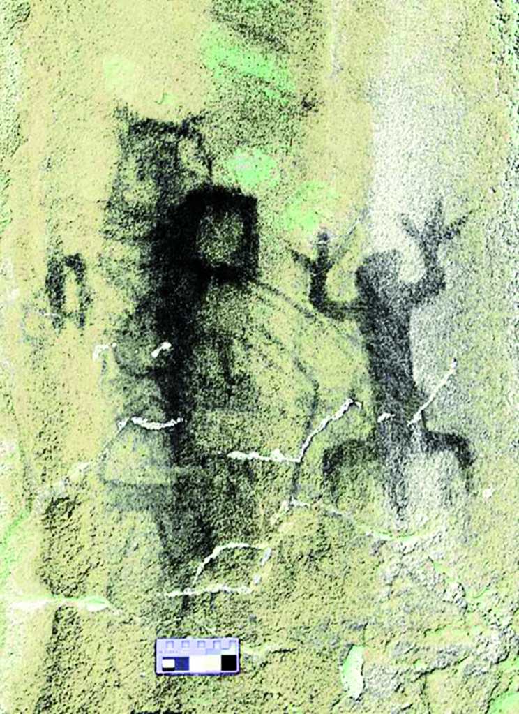
This site was visited by different healing specialists, such as bones, yerberos and midwives, who also carried out rituals to promote the fertility of the fields by means of rain petitions ceremonies, in addition to rites of initiation related to human and animal fertility. These rituals and practices are embodied in the basaltic rock panels of the sacred site.
Astronomical complex
The knowledge of the Mayan calendars had its origin in the Tajumulco region, which served as a natural marker of the solstical passage from the Tacaná volcano. This volcanic complex represents what is now known as group E in pre -Columbian astronomical observatories. In the archaeological site of Tajumulco, iconographic elements have been found in paintings and monuments that record the course of time through the Movement of the Sun. The astronomical observation of solar and moon cycles was fundamental for the measurement of time and the celebration of rituals in honor of life and fertility.
Tajumulco is also an area rich in minerals, such as quartz, sulfur, serpentine, lapislázuli and iron oxides, used in rituals and cave paintings in sacred sites. Independent investigations initiated in 2020 have rediscovered these rock art spaces.