
The eruption of the Fire Volcano, the June 3, 2018, marked a before and after in the Surveillance of the Volcanic activity in Guatemala.
This disaster, which, according to official figures, left 319 dead, evidenced the urgency of modernizing monitoring and response to volcanic emergencies.
Since then, the National Institute of Seismology, Volcanology, Meteorology and Hydrology (Insivumeh) has strengthened its ability to monitor the three active volcanoes of the country: Pacaya, Santiaguito and Fire.
According to Roberto Mérida, from the Volcanology Department of Insivumeh, the Amount as the quality of monitoring instruments volcanic, which allows a more precise detection of eruptive activity.
Innovation in technology for volcanic monitoring
Mérida detailed in an interview with Free press that, before 2018, many of The devices were old or disused, which limited the accuracy of the data collected.
With the modernization and Expansion of the monitoring networkthe ability to interpret the Seismic and acoustic signals of volcanoes, facilitating the emission of more accurate alerts and reducing the probability of false alarms.
Among the improvements implemented is the installation of multiparamétric stations that integrate various sensors in the same site.
These stations, donated by the Volcanic Disaster Program (VDAP) of the United States Geological Service (USGS)they have:
- Broadband seismometers
- Infrast sensors
- Web cameras
- Meteorological stations
These technologies have been key to improving the detection and monitoring of phenomena such as lahares and pyroclastic flows.
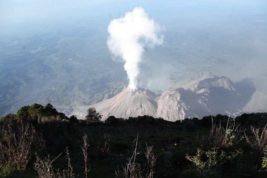
Fire volcano monitoring
In response to the 2018 tragedy, the surveillance of the different types of flows that descend from the volcano of fire has been prioritized.
Currently, there are seven installed seismometerscompared to the two that existed before the eruption.
They have also installed web cameras strategically located to monitor the crater and the ravines where the lahares are formed.
Some of these cameras broadcast live on platforms such as YouTubewhile others capture images every 40 seconds and send them via cell data.
Satellite monitoring has also improved thanks to the use of satellite images Sentinelof the European Space Agency (ESA)and Landsatof the POT.
These tools allow a detailed observation of the ash and the magmatic gases, complementing the information obtained on the ground.
In addition to these technological improvements, evacuation and communication protocols with surrounding communities have been strengthened.
Early alert systems that include sirens and text messages have been implemented to warn about possible eruptions or real -time lahars.
Emergency community brigades have received training to act more effectively in case of a volcanic event.
Its most recent eruption, which occurred among the 9 and March 10, 2025He tested these advances and showed that evacuation protocols have significantly improved.
Although it may seem a simple process, Mérida explains that coordinating the displacement of hundreds of people in a matter of minutes is a highly complex work.
The effectiveness of the response depends on the speed in the issuance of newsletters and alerts, as well as the joint work between the Insivumeh, the National Coordinator for Disaster Reduction (Conred) and the communities.
Despite these advances, the Fire volcano It continues to represent a high risk due to its constant activity.
https://www.youtube.com/watch?v=L9ra010xxvc
Moderate explosions and the expulsion of incandescent material continue to affect nearby populations, which makes continuous monitoring and preparation indispensable before possible eruptive events of greater magnitude.
Advances for the Santiaguito volcano
Although the fire volcano has periodic eruptions, the Santiaguito volcano is considered the most dangerous in Guatemala due to its constant activity.
Before 2020, it had a network of six seismometers, the majority in disuse due to lack of maintenance.
Thanks to a project funded by the Swiss cooperation for development in Central AmericaIt was possible to rehabilitate old stations and modernize the monitoring network.
Currently, the volcano has 13 operational stations, including six multiparametric.
This has allowed improving the detection of explosions and lava flows, as well as making a more effective monitoring of changes in eruptive activity.
Pacaya volcano
The monitoring of Pacaya volcano It has also been reinforced. Between 2020 and 2021, the VDAP donated two multiparamétrica stations And, in 2024, another was incorporated with seismometer thanks to the collaboration with the University of Tulsa and the Michigan Technological University of the United States.
These teams have allowed more precise monitoring of the activity of the volcano, known for its frequent Strombolian eruptions.
International cooperation
The modernization of volcanic monitoring in Guatemala has been possible in large part thanks to international cooperation.
In addition to the contributions of USGS and the Swiss cooperationInsivumeh has received support from foreign universities and has allocated own funds to strengthen the surveillance of active volcanoes.